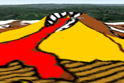
 A screen Shot of the Mt St Helens Volcano in Google Earth showing an overlay map where red is the extent of a Pyroclastic flow.
What: Content designed to be viewed in 3D environment rather than as a simple 2D map. Virtual Globes such as GEarth are migrating into browsers and separate Virtual Globe clients are disappearing. The discussion in the post refers to both browser and client based Virtual Globes.
Use When and Why: The primary reason for using a Virtual Globes is the 3D nature of the visualization needed as in the screen shot, the map as a flat map would lose value from the 3D visualization shown. Other major uses of virtual globes include viewing the ocean floor from below sea level, the altitude and location of a plane's path and 3D buildings.
However, there are also other subtle reasons why 3D can be helpful. For instance, the Mercator projection of the globe which is used by map systems like Google Maps represents the arctic as a strip of white along the top of the map. If you are looking at the arctic as a whole then being able to view it from above the North pole as it really is represents a much better visualization.
I also suspect that being able to fly from place to place on a Globe helps people locate and orient themselves when they are taken to a new place when compared with zooming in and out on a flat 2D map. This idea needs further investigation.
Functionality not available in Browsers:
At the time of writing Virtual Globes also offer a range of functionalities not available in browser 2D systems. For example, Google Earth offers:
- An easy way to mash data sets together (KML, but other formats are supported)
- Producing tours for those who don't want to write KML directly
- Accessing a range of data such as the multiple Google Ocean layers in the layers column
How: Create KML:
- Directly from GEarth ,
- Via a google docs spreadsheet
- Programming text output directly (e.g. using PHP).
Examples:
- 3D buildings: Effiel Tower
- Underwater tour: Part of this video
No comments:
Post a Comment