IMHO its the most important instance of what is becoming known as VGI (Volunteered Geographic Information) yet to occur on the web. Those who organised it and those who just took part deserve a great deal of respect, I think we’re going to see a lot more mapping like this in future emergency situations and this was the first example. As they point out, key to this was the rapid publication of high quality satellite imagery.
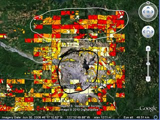
As it happens, I’ve just completed PolyMap a VGI based educational project for Southampton University where we got the students to create a thematic map via a web service based on Google Maps API* . They mapped tree cover around Mt St Helens volcano in USA to see how trees had recovered since the 1980 eruption, click the image to see a demo:
Thoughts for Others considering setting up VGI: Most of the following was obtained via written student feedback:
- I gave students a background presentation of how VGI related to crowd sourcing and other VGI projects (here as a PDF), the students said this helped them realise what they were doing was a valid technique beyond the Mt St Helens problem. Could be useful as a motivator in non-educational situations?
- I split the area into a grid and assigned them a square each. This helped in getting the entire area mapped although there was some problems with people working in the wrong square etc.
- They complained that the classification scheme was difficult to apply whilst I had thought it was fairly simple and well explained. It goes to show that great care is needed in defining and then explaining classification schemes. My video tutorials on how to produce the map were very popular, fool proof documentation and instructions are well worth the investment of time.
- They liked the fact that I collated the data and interpreted it in a presentation after they had finished and working in groups on a shared problem.
- Advances in Google MyMaps since we started the project mean it would have been possible and much easier to do this project using Google MyMaps rather than the bespoke PolyMap service.
- Student feedback was the most positive feedback I've had for a long time!
- The 1980 Mt St Helens eruption is a great topic to teach using technology, satellite images, youtube clips and photographs from USGS are out there in abundance. I think having an interesting context (the eruption) is possibly more important to the learning than the quality of the VGI data.
No comments:
Post a Comment